Electrical Resistivity Tomography (ERT) and Induced Polarization (IP)
Main Areas of Application
· Mineral and coal exploration
· Geotechnical investigations
· Hydrogeology
· Environmental studies
· Engineering & infrastructure
· Archaeology
Understand Subsurface Conditions with Confidence
Electrical Resistivity Tomography (ERT) and Induced Polarization (IP) are proven geophysical survey methods used to image subsurface conditions non-invasively. These techniques are widely applied in geotechnical investigation, groundwater exploration, and engineering risk assessment.
At GeophysicsPro, we deliver high-resolution resistivity imaging integrated with geological and geotechnical interpretation, helping you reduce uncertainty and make reliable project decisions.
👉 Request a consultation to discuss your project requirements
Why Use ERT & IP for Subsurface Investigation?
Non-invasive and cost-effective alternative to extensive drilling
Provides continuous 2D/3D subsurface imaging
Detects weak zones, fractures, and groundwater pathways
Reduces uncertainty in engineering design and site investigation
Effective in complex geological and tropical weathering environments
These advantages make ERT & IP surveys essential tools for modern subsurface investigation workflows.
Key Applications of Resistivity & IP Surveys
Geotechnical Investigation
Foundation assessment and bedrock mapping
Identification of weak zones and weathered materials
Fracture and fault zone detection
Subsurface variability analysis
Groundwater Exploration
Aquifer delineation and depth estimation
Mapping groundwater flow pathways
Seawater intrusion detection
Hydrogeological characterization
Infrastructure & Construction
Subsurface investigation for roads and buildings
Void and cavity detection
Utility corridor assessment
Pre-construction risk evaluation
Environmental Studies
Contamination and leachate detection
Landfill and waste site investigation
Monitoring subsurface fluid movement
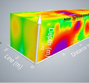
Road Landslide
How Electrical Resistivity & IP Surveys Work
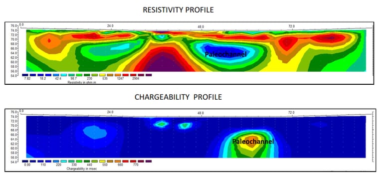
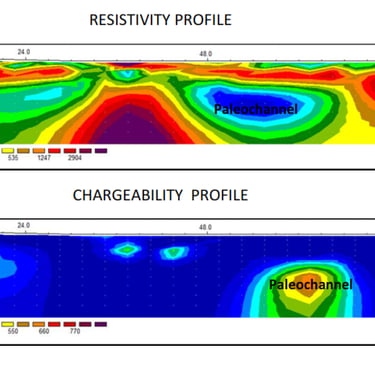
Electrical Resistivity Tomography (ERT)
ERT measures the electrical resistivity of subsurface materials by injecting current into the ground.
High resistivity → competent rock, dry materials
Low resistivity → clay-rich or water-saturated zones
This allows accurate imaging of:
Lithological boundaries
Bedrock depth
Groundwater zones
Induced Polarization (IP)
IP measures chargeability, indicating the ability of subsurface materials to store electrical charge.
High chargeability → clay-rich or conductive materials
Low chargeability → clean sands or massive rock
IP improves interpretation by distinguishing:
Clay vs water saturation
Material composition in complex environments
Resistivity vs Chargeability
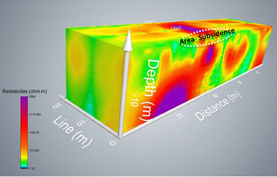
Integrated Interpretation for Reliable Results
Combining ERT and IP provides a multi-parameter subsurface model, reducing ambiguity:
Resistivity defines structure and fluid distribution
Chargeability refines material characterization
This integrated approach is particularly effective for:
Fractured rock environments
Tropical weathering profiles
Urban subsurface complexity
Our Workflow for ERT & IP Surveys
1. Survey Design
Objective-based planning
Selection of optimal electrode arrays
Depth and resolution optimization
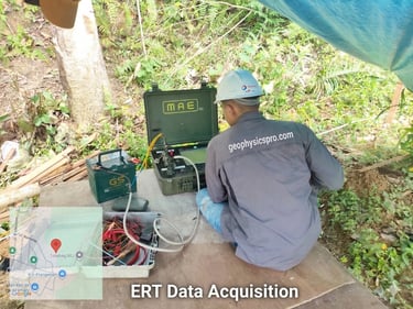
2. Data Acquisition
Multi-electrode resistivity and IP systems
High-density data collection
Field quality control and noise reduction
Equipment & Technology
We utilize advanced multi-channel resistivity meters with automated electrode switching to ensure:
High-resolution data acquisition
Reliable signal quality in challenging environments
Efficient field operations
3. Data Processing & Inversion
Industry-standard inversion (RES2DINV / RES3DINV)
Noise filtering and data validation
Generation of true resistivity and chargeability models
4. Interpretation
Integration with geological and geotechnical data
Identification of layers, anomalies, and structures
Engineering-focused interpretation
5. Deliverables
You receive clear, decision-ready outputs:
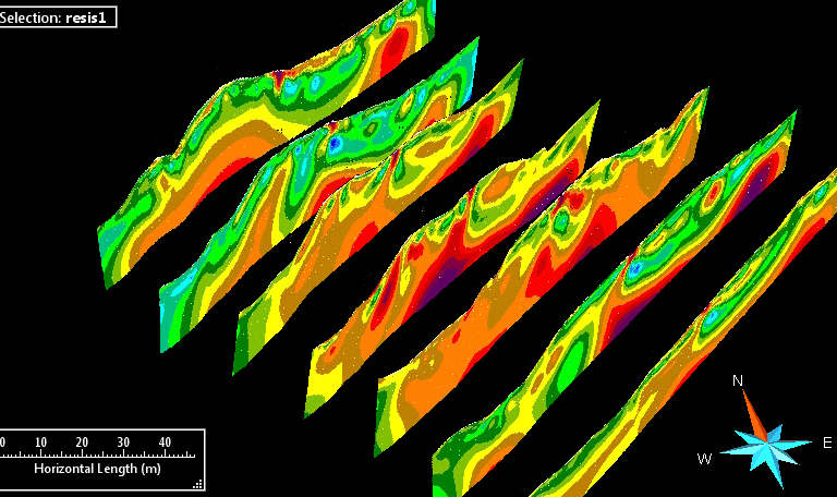
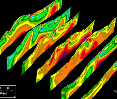
2D and 3D resistivity & chargeability sections
Interpreted subsurface profiles
Identification of risk zones (voids, weak zones, fractures)
Technical report with actionable recommendations
Applications in Real Projects
Mapping subsurface fractures causing structural damage
Identifying slip surfaces in landslide-prone areas
Detecting voids beneath infrastructure
Delineating groundwater systems
Combine with Other Geophysical Methods
For improved results, ERT & IP surveys can be integrated with:
MASW for soil stiffness and shear wave velocity
GPR for shallow high-resolution imaging
This multi-method approach provides a comprehensive subsurface investigation solution.
Value to Your Project
Our resistivity and IP survey services help you:
Reduce uncertainty in subsurface conditions
Optimize drilling and investigation costs
Improve engineering design decisions
Detect geohazards early
Increase project safety and reliability
Why Choose GeophysicsPro
Integration of geophysics with geotechnical interpretation
Experience in complex geological and tropical environments
Use of advanced inversion and modeling techniques
Focus on decision-ready results, not just data
Flexible full-service and modular solutions
Frequently Asked Questions (FAQ)
What is a resistivity survey used for?
Resistivity surveys are used to image subsurface conditions, identify groundwater, detect weak zones, and support geotechnical investigations.
How deep can ERT investigate?
Depth depends on electrode spacing, but typically ranges from a few meters to over 100 meters.
Is ERT better than drilling?
ERT does not replace drilling but significantly reduces uncertainty by providing continuous subsurface imaging between boreholes.
When should IP be used with ERT?
IP is recommended when distinguishing between clay-rich materials and water saturation is critical.
Start Your Subsurface Investigation with Confidence
Whether you are planning infrastructure, assessing geohazards, or exploring groundwater resources, our ERT & IP survey services provide reliable, high-resolution subsurface insights.
👉 Contact us today to discuss your project and get a tailored survey solution