Integrated Geophysical & Geotechnical Investigation Services
Area Applications
Foundation Design
Infrastucture Development
Slope Stability & Design Analysis
Urban & Complex Environment
Bridging Subsurface Imaging with Engineering Parameters for Reliable Design and Risk Reduction
Reduce Uncertainty Between Data and Design
Traditional site investigations often rely on limited borehole data, leaving large uncertainty between investigation points. Geophysical surveys provide continuous subsurface imaging—but without engineering interpretation, their value remains underutilized.
At GeophysicsPro, we integrate geophysical data with geotechnical parameters, transforming subsurface information into engineering-ready models that directly support design, risk assessment, and construction decisions.
👉 Request a consultation to integrate geophysics into your geotechnical investigation
Why Integrate Geophysics with Geotechnical Investigation?
Boreholes provide accurate but limited point data
Geophysics provides continuous spatial coverage
Integration reduces uncertainty between boreholes
Enables interpolation of engineering properties across the site
Improves reliability of design models
👉 The result: better decisions with fewer unknowns
What We Integrate
We combine multiple datasets into a unified subsurface model:
Geophysical Data
Electrical resistivity (ERT/IP)
Shear wave velocity (MASW)
Compressional velocity (SRT)
Ground Penetrating Radar (GPR)
Geotechnical Data
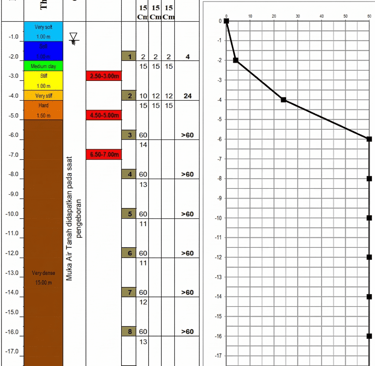
Borehole logs and lithology
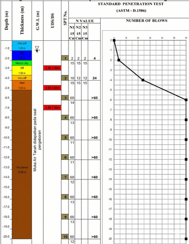
Standard Penetration Test (SPT)
Laboratory test results
Rock Quality Designation (RQD)
From Geophysics to Engineering Parameters
One of our core strengths is converting geophysical measurements into engineering-relevant parameters.
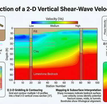
Shear Wave Velocity (Vs) → Soil Stiffness
Determines deformation behavior
Used in seismic design (Vs30)
Correlates with soil density and compaction
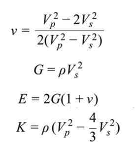
Vp & Vs → Elastic Moduli
From seismic data, we derive:
Poisson’s ratio (ν)
Shear modulus (G)
Young’s modulus (E)
Bulk modulus (K)
👉 These parameters are essential for:
Settlement analysis
Foundation design
Numerical modeling
Resistivity → Material & Fluid Conditions
Differentiates clay, sand, and rock
Identifies groundwater zones
Detects weak or saturated layers
Integrated Workflow
Our approach follows a structured, engineering-focused workflow:
1. Investigation Planning
Define engineering objectives
Identify required parameters (Vs, modulus, stratigraphy)
Design integrated survey strategy
2. Data Acquisition
Geophysical surveys (ERT, MASW, SRT, GPR)
Borehole and in-situ testing
3. Data Processing
Geophysical inversion (resistivity, velocity models)
Data quality control
4. Data Integration
Correlation between boreholes and geophysical models
Calibration of geophysical responses
Interpolation between investigation points
5. Engineering Interpretation
Derivation of elastic moduli
Identification of weak zones and anomalies
Development of subsurface engineering model
6. Deliverables
Integrated 2D/3D subsurface models
Engineering parameter maps (Vs, modulus, resistivity)
Risk zone identification
Technical report for design support
Applications
Foundation Design
Improved understanding of soil stiffness and variability
Better estimation of bearing capacity and settlement
Infrastructure Development
Subsurface characterization for roads, bridges, and buildings
Detection of hidden risks (voids, weak zones)
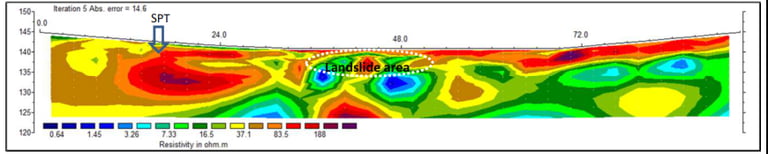
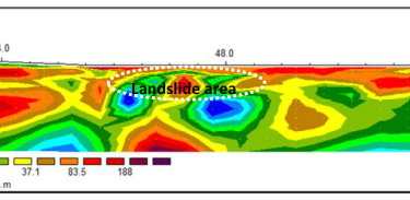
Slope Stability & Landslide Analysis
Identification of slip surfaces
Mapping of saturated and weak layers
Urban & Complex Environments
Fault and fracture mapping
Subsurface variability in built-up areas
Value to Your Project
Our integrated approach delivers:
Reduced uncertainty in subsurface models
Fewer boreholes required (cost efficiency)
Continuous spatial understanding
Engineering-ready parameters (not just data)
Improved safety and design reliability
Why Choose GeophysicsPro
Unique focus on geophysics–geotechnical integration
Ability to convert data into engineering parameters
Experience in complex geological environments
Strong emphasis on decision-oriented outputs
Flexible collaboration with consultants and contractors
Frequently Asked Questions (FAQ)
Why not rely only on boreholes?
Boreholes provide accurate data at specific points but cannot capture variability between locations. Integration with geophysics fills these gaps.
Is geophysical data reliable for engineering design?
Yes, when properly calibrated with borehole and laboratory data, geophysical results significantly enhance engineering models.
Can this reduce investigation costs?
Yes. Integrated surveys often reduce the number of boreholes required while improving overall understanding.
What is the main benefit of integration?
It transforms fragmented data into a continuous, interpretable subsurface model.
Start Integrating Data for Better Decisions
If your project requires reliable subsurface understanding for design, risk assessment, or construction, our integrated geophysical–geotechnical services provide the clarity you need.
👉 Contact us today to discuss your project and develop an integrated investigation strategy

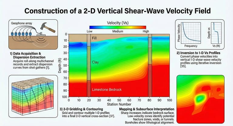
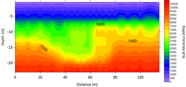
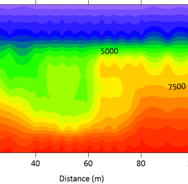
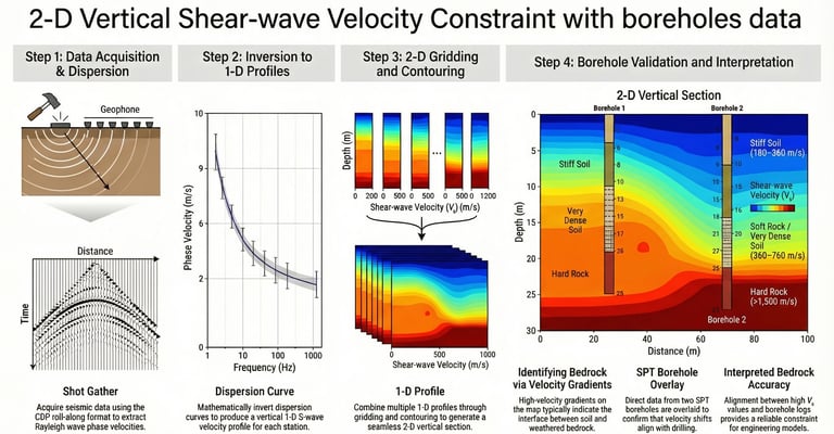
A notable lateral variation is observed between 40m and 70m distance, where a deeper "pocket" of lower modulus material may indicate a localized zone of higher porosity or soil saturation