Multichannel Analysis of Surface Waves
Through shear wave velocity profiling (Vs), MASW helps engineers:
• Estimate soil stiffness
• Identify weak layers
• Support foundation design
• Assist in seismic site classification
Multichannel Analysis of Surface Waves (MASW)
Multichannel Analysis of Surface Waves (MASW) is a non-destructive geophysical method used to evaluate subsurface stiffness by measuring the velocity of seismic surface waves, specifically Rayleigh waves. Since the propagation velocity of these waves is directly related to the elastic properties of the ground, MASW has become a standard tool for engineering, environmental, and seismic hazard applications.
The Physics of Dispersion
The core principle behind MASW is dispersion: in a layered medium, surface waves of different wavelengths (or frequencies) travel at different phase velocities. Shorter wavelengths (high frequencies) probe the shallow layers, while longer wavelengths (low frequencies) penetrate deeper. By measuring how these velocities change across a frequency spectrum, geophysicists can reconstruct the vertical profile of the subsurface.
The Three-Step Process
The MASW method typically follows a rigorous three-stage workflow:
Data Acquisition: A linear array of geophones (usually 12, 24, or more) is deployed on the surface. A seismic source, such as a sledgehammer or a weight drop, generates waves that are recorded simultaneously across the multichannel array.
Dispersion Analysis: The recorded "shot record" is transformed from the time-space domain into the frequency-velocity domain (often called a phase-velocity spectrum or "overtone" image). The analyst identifies the fundamental mode of the Rayleigh wave to create a dispersion curve.
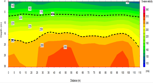
Inversion: Mathematical algorithms are used to "invert" the dispersion curve, iteratively calculating a 1D vertical profile of Shear-Wave Velocity (Vs).
Applications and Advantages
MASW is highly valued because Vs is a direct indicator of shear modulus (G ), a fundamental parameter for calculating soil stiffness and strength. It is frequently used for:
Seismic Site Classification: Determining Vs30 (the average shear-wave velocity in the top 30 meters) for building code compliance.
Mapping Bedrock: Identifying the depth to competent rock or identifying weathered zones.
Detecting Anomalies: Locating voids, sinkholes, or zones of soil liquefaction potential.
Compared to traditional borehole methods, MASW is more cost-effective, covers more ground in less time, and provides a representative bulk measurement of the site rather than a single point of data.